Tutorials/Post - Remote Sensing, GIS, Earth System, Geo-AI/ML

Skip to main text
  • Home
  • Remote Sensing
  • Web GIS
  • Article archive

Compile/Install AERMOD on Linux


AERMOD Modeling System

The AERMOD Modeling System is a plume model designed for steady-state condit…

Read More

Category: Remote Sensing

  Suman.Sanjel ,   2024-02-12 ,   2775

Creating a Map with XYZ Tiles using Geopandas, Matplotlib, Contextily, and XYZServices


In this blog post, we will explore how to create an matplotlib map (2D map) with XYZ tiles using Py…

Read More

Category: Web GIS
  GIS     SDI     Web GIS  
  Suman.Sanjel ,   2023-12-07 ,   4161

Automating GeoTIFF Data Upload to GeoServer using Python


In this blog, we'll explore how to automate the process of uploading GeoTIFF files to GeoServer usi…

Read More

Category: Web GIS
  Web GIS  
  Suman.Sanjel ,   2023-11-05 ,   2694

ol-plus - TimeDimensionTile


What is ol-plus?

ol-plus is the javascript library build for openlayers which has multiple extensio…

Read More

Category: Web GIS
  Web GIS  
  Suman.Sanjel ,   2022-05-01 ,   3248

THREDDS Data Server


THREDDS stands for "Thematic Realtime Environmental Distributed Data Services". The THREDDS Data Se…

Read More

Category: Web GIS
  Remote Sensing  
  Suman.Sanjel ,   2022-02-04 ,   3327

Zonal statistics for each time step in a NetCDF data using rasterstats in python


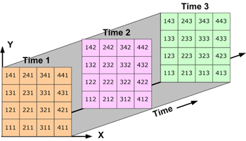
NetCDF is a common format when we are talking about the scentific data. Here we can see an example …

Read More

Category: Remote Sensing
  RS     Remote Sensing  
  Suman.Sanjel ,   2022-01-11 ,   3657

Views

  • Creating a Map with XYZ Tiles using Geopandas, Matplotlib, Contextily, and XYZServices - 4161 views
  • Zonal statistics for each time step in a NetCDF data using rasterstats in python - 3657 views
  • THREDDS Data Server - 3327 views
  • ol-plus - TimeDimensionTile - 3248 views
  • Compile/Install AERMOD on Linux - 2775 views
  • Automating GeoTIFF Data Upload to GeoServer using Python - 2694 views

Categories

  • Remote Sensing
  • Web GIS

Recent articles

  • Compile/Install AERMOD on Linux
  • Creating a Map with XYZ Tiles using Geopandas, Matplotlib, Contextily, and XYZServices
  • Automating GeoTIFF Data Upload to GeoServer using Python
  • ol-plus - TimeDimensionTile
  • THREDDS Data Server
  • Zonal statistics for each time step in a NetCDF data using rasterstats in python

Tag

Web GIS SDI GIS Remote Sensing RS

Features

  • Login
Home  |  About | Contact | Privacy Policy
Copyright© 2026